Community Resilience
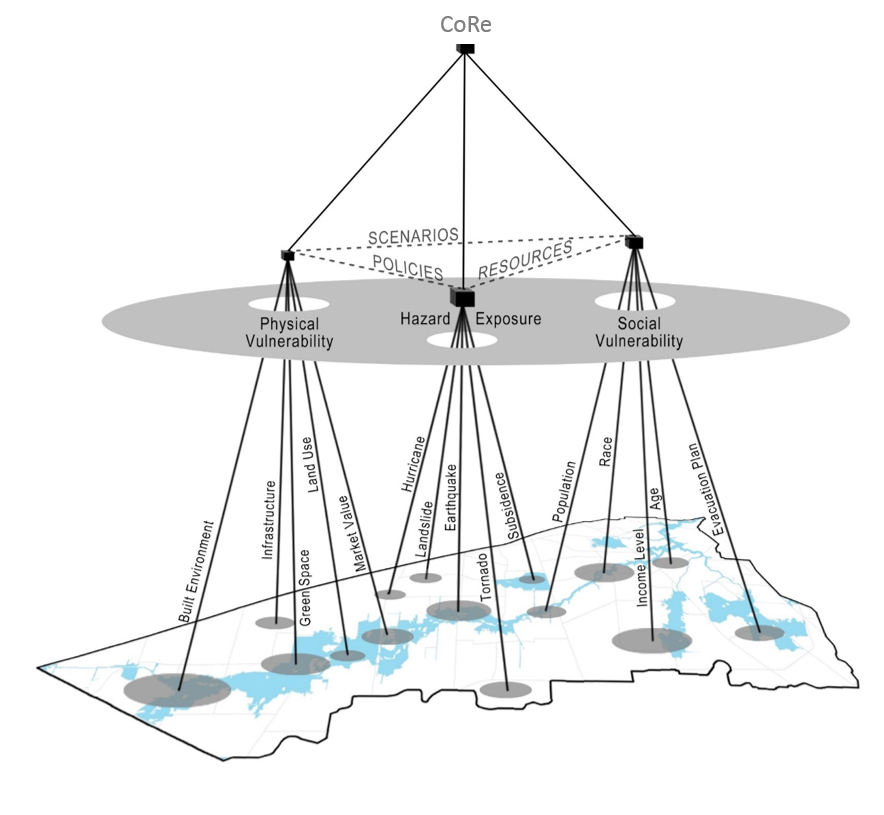
The Community Resilience (CoRe) Program of the Institute for Sustainable Communities seeks to generate and apply research on the impact of natural hazards to socially and physically vulnerable populations and neighborhoods and utilize said research to develop strategies to mitigate and adapt to disasters, with an emphasis on community engagement and participatory processes.
The program seeks to extend the mission of the Hazard Reduction and Recovery Center (HRRC) by exploring new and transformative directions to create and disseminate research findings to communities and practitioners to better mitigate, prepare for, respond to and recover from disasters. It is comprised of faculty, professionals, staff and students with backgrounds in urban planning, landscape architecture, landscape ecology, urban hydrology and low impact development. Our work is strongly focused on issues related to land use change and urban development patterns, ecosystem services, water resource conservation, stormwater flooding and storm surge, green infrastructure and climate change and has been supported by many funders, including the Department of Homeland Security, the National Science Foundation and Texas SeaGrant.
Collaborators:
Our research and outreach focuses on the intersection of community resilience and biodiversity. We are also closely linked to the highly acclaimed HRRC. As such, we collaborate with researchers in the TAMU Colleges of Architecture, Geosciences, Liberal Arts, Agriculture and Life Sciences, the School of public Health and Bush School of Government as well as experts at the Institute of Sustainable Coastal Communities. We also work with numerous other federal, state, and local agencies and organizations for research purposes and participatory design/planning projects and have a working relationship with many ongoing projects at Texas A&M-Galveston.
Discovery Initiative Highlights
Aggie B.L.U.E. Print Laboratories: Building Lasting University Environments a Multi-Disciplinary Teaching Opportunity
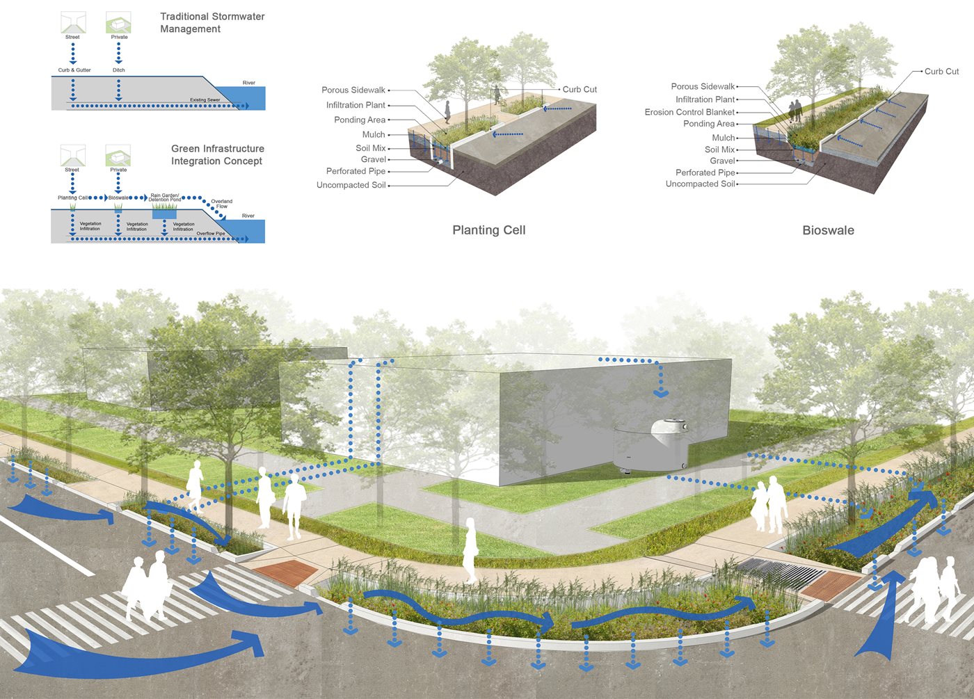
Low Impact Development (LID), is increasingly utilized in sustainable design/development, minimizing the impact of impervious land cover. LID is an innovative approach treating stormwater at the source, using uniformly distributed facilities such as stormwater collection devices, filtering systems, and water reuse mechanisms. This project seeks to educate and train students in LID alternatives to traditional stormwater management through hands-on outdoor classroom activities involving development, installation, monitoring, management, and evaluation of stormwater management designs within interactive test plots. Two sites on the Texas A&M University campus are being developed, one in which the primary challenge is runoff from building roofs and the other entails management of a large parking lot and turfgrass area effluent. Tasks are being carried out by students across three colleges (agriculture, architecture and engineering), including the Landscape Architecture and Urban Planning, Horticultural Sciences, Civil Engineering, and Biological and Agricultural Engineering departments. Provisions for solutions to complex hydrologic issues are being explored, assessed, and showcased as outdoor labs and interactive public exhibitions. Landscape Architecture and Urban Planning students are providing the designs, Horticultural Sciences students are providing plant materials suggestions, propagating and growing plants for the project, and Engineering students are planning monitoring and environmental quality measurements. The three year project employs long-term involvement in hands-on learning activities by an estimated 300 or more students per year and will result in solutions to two long-term water management problems on the Texas A&M University campus. Project objectives, plans and current accomplishments will be addressed.
View the published abstract from the American Society of Horticultural Science Conference
Neighborhood Detox: Enhancing Resilience in a Hazard Vulnerable Area
This a service learning project utilized an interdisciplinary participatory process in which a master plan was developed for Manchester neighborhood. One of Houston’s oldest neighborhoods, Manchester is surrounded by industries, resulting in one of the highest impairments and lowest water qualities in the state. Nearly 3/4 of the neighborhood surface is impervious, there is a lack of open space and the infrastructure in place is not effective in preventing flooding. In cooperation with Texas Environmental Justice Advocacy Service (t.e.j.a.s.), Charity Productions and Furr High School’s Green Ambassadors, provisions for land use and open space planning, green infrastructure and hydrological management were made. Participatory involvement was initiated first by an introductory meeting allowing residents to discuss on-site problems; this assisted in both helping identify areas of pooling and flowing of floodwaters as well as options to treat vulnerable areas. A second meeting involved a presentation to the community of the initial site analysis findings. Third and fourth meetings involved a feedback loop between community members and designers in which master plans were presented and critiqued by neighborhood members. Responses from the community were utilized to revise the plans. The design was able to 1) inventory and locate flood-prone areas and on-site problems, 2) spatially locate new land uses, 3) develop desired functions for proposed open spaces, 4) suggest new job opportunities for enhancing the local economy and 5) designate green infrastructure to mitigate flood issues.
View the National Honor Award received by the project by the American Society of Landscape Architects, Community Service Category
The Ike Dike: Design Strategies for Integrating Surge Protection Infrastructure
Storm surge protection infrastructure systems have proven effective in protecting coastal communities prone to hurricane storm surge and resultant flooding. Due to the size and required system contiguity, many systems have resulted in adverse ecological and cultural effects. Ecological alterations include disturbances to water exchange, increased land cover conversion and habitat fragmentation while cultural disruptions include physical and visual coastal disconnection, decreased beach area and challenges to commercial and tourism activities tied to coastal environments. This project generates a comprehensive storm protection system for the Houston-Galveston MSA which preserves and enhances ecological processes and cultural practices into an integrated system. This system, called the Ike Dike, is a projected $6 billion coastal spine which seeks to protect the Port of Houston from a 10,000-year flood. While the protection of flood-vulnerable populations is the primary goal of the coastal spine, integration of the infrastructure into the landscape is a key objective. Multifunctional strategies and program options are being established to achieve this integration including a mixture of fortified dunes, seawalls and channel gates offering protection up to 20-25 feet above MSL. Both structural and non-structural mechanisms for ecologically and culturally integrating surge protection infrastructure are evaluated. These mechanisms are then applied into a large-scale multifunctional framework using four unique environments in western Galveston Island, TX.

Lone Star Groundwater Conservation District Site Plan
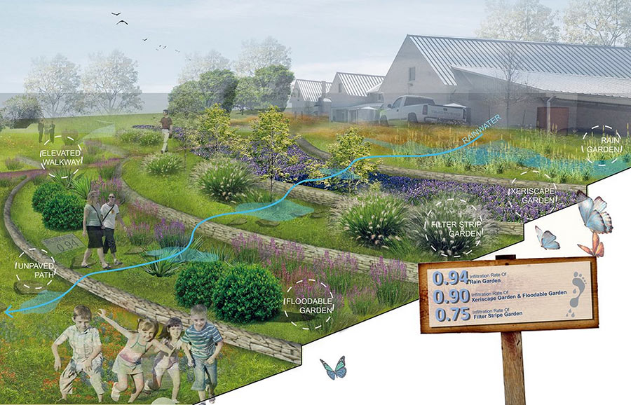
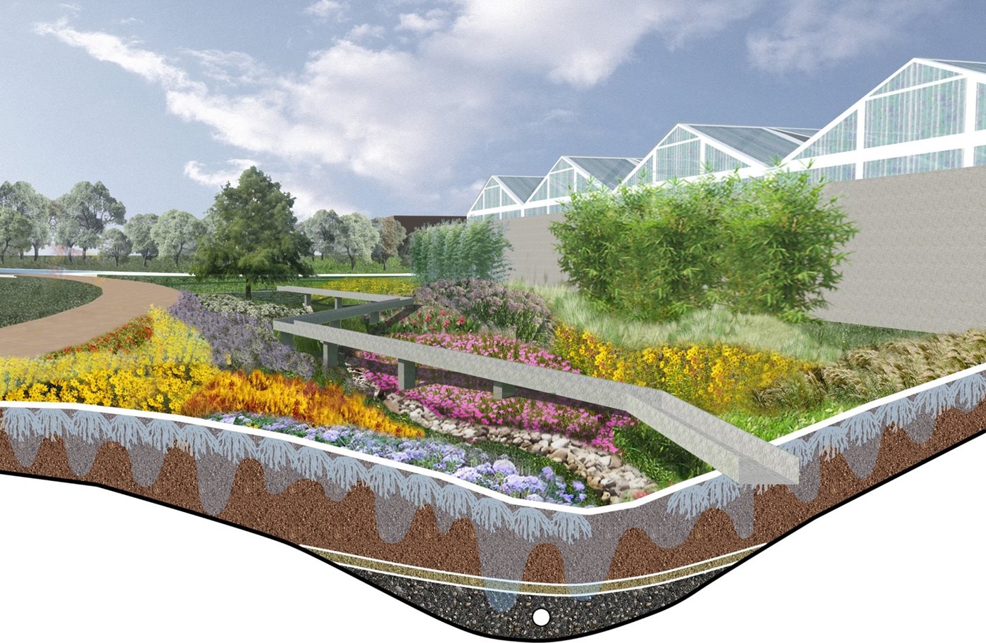
Land planning strategies emphasizing stormwater runoff management such as Low Impact Development (LID) have become increasingly utilized in design projects to help minimize the impact of impervious land cover. While several design guideline manuals exist, not many integrated approaches attempt to investigate the actual effectiveness of LID based designs. This project both designs and tests the efficacy of LID implementation and introduces an approach to integrating design with LID technologies which promote education and awareness. The framework presented serves as a three tiered design performance measurement structure in which other LID based designs should seek to mimic. First, LID facilities (mechanical or biological) are categorized into 3 typologies based on hydrological functionality: capture, convey, and clean (treat). Runoff amounts are then measured according to these typologies. Second, each LID facility becomes an educational feature through an innovative hierarchical way-finding system which illustrates the ratio of infiltrated water to total rainfall. Monthly rainfall data, monthly evapotranspiration data, and post-design runoff coefficients of surface materials are integrated to measure infiltration ratios for each LID facility. Finally, the vegetation palette effectiveness is evaluated based on draught tolerance, water treatment capacity, and maintenance requirements relative to site conditions. Successfulness was assessed using total runoff reduction and increased human interactivity in association with each LID facility. Additionally, water demand reduction and water quality improvements were projected based on current usage patterns. Economic benefits were quantified by calculating saved water treatment costs and city water costs.
See an article on the design of the site from the Architects Newspaper