The Network of Networks
Date: 11/14/2018
Author: Cassie Oswood, Public Relations Manager
Dr. Ali Mostafavi, Dr. Philip Berke and Dr. Bryce Hannibal presented their research on the Integrated Assessment of Social, Institutional, and Infrastructure Networks in Flood Hazard Mitigation Planning and Resilience Governance: Study of Houston in Hurricane Harvey to the IfSC. While their team of researchers is made of up 10 professionals, Mastafavi, Berke and Hannibal led the presentation and discussed whether the local and regional plans limit or exacerbate the problem of resiliency and hazard mitigation planning.
Their ‘Network of Networks’ project analyzes the relationships between regional and local stakeholders, regional and local plans, and interdependent physical infrastructure networks. They wanted to find out to what extent responses to hazards are networked and collaborated or siloed. This question is important for disasters because solutions demand collaboration across fields.
In looking at infrastructure, the research team conducted road network analysis and compared road closures to residents’ hardships. They also examined the conflicts in network plans and the social network of stakeholders. When analyzing the network of stakeholders, the researchers surveyed hazard mitigation planning preference, factors that contribute to flooding, policy preferences related to flood resilience and hazard mitigation and collaboration on flood mitigation efforts between different actors. From these analysis, the researchers determined that governmental bodies usually have more collaboration (higher degree) (e.g. Harris County, City of Houston, HGAC).
They reported that future analyses will focus on empirical analyses of Institutional Collective Action framework, intergovernmental collaboration, collaboration across distinct categories of organizations and identifying how collaboration influences policy preferences.
The second part in the research project analyzes the network of plans. This research is focused on integrating the plan for resilience scorecard in Harris County. The resilience scorecard is a tool used to evaluate the degree to which networks of plans are integrated to reduce vulnerability. By overlaying the policy score for individual plans, the scorecard is able to produce a composite policy score that determines of the plans increase or decrease vulnerability to disasters. As Dr. Jaimie Masterson commented, “This is important when you go into a community because it encourages conversation.”
The final part of the project analyzes infrastructure networks. This research focuses on the interdependencies of infrastructure. For example, the analysis is able to determine the co-location and co-evolution interdependencies of flood control networks and road networks. In the temporal analysis of the road networks, the team analyzed the structural changes in the road networks at the super neighborhood level over time and focused on areas affected by water release from Addick’s and Barker’s reservoirs (Briar Forrest Super-neighborhood). The team also obtained surveys of residents’ self-reported hardship due to road closure in each super-neighborhood. The research team will continue to further explore the relationship between residents’ hardships and infrastructure disruptions and analyze interdependences with flood-control and emergency response infrastructures.
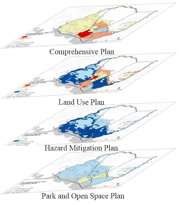
The above image shows examples of layering each of the plans onto a single geographic region
In concluding the rapid research of this project, it was determined that there was a low level of collaboration across different stakeholders about flood mitigation prior to Harvey. This project will officially transition from a rapid research project to a long term research project starting January 1, 2019. The results and data collected from this project can help local governments/stakeholders create and implement better tailored resiliency and disaster mitigation plans for their cities.