The Plan Integration for Resilience Scorecard: Spatially Evaluating Networks of Plans to Reduce Haza
Date: 3/23/2017
Author: Matthew Malecha, Doctoral Student
Wise land use planning is one of the most effective ways to prevent or reduce damage from natural hazards such as flooding. Communities adopt multiple plans that guide their future development and management, and many of the policies contained within such plans can affect vulnerability to hazards. For instance, a hazard mitigation plan that prohibits new construction in or near a floodplain is likely to reduce vulnerability by minimizing the number of people and structures in harm’s way, whereas a comprehensive plan that mentions increased development in the same area might amplify it. Similarly, a community that acknowledges and accounts for hazards throughout a well-integrated network of plans is likely to be more resilient than one in which the various plans conflict and hazards are downplayed. The Plan Integration for Resilience Scorecard, developed by a team of researchers at Texas A&M University’s Institute for Sustainable Communities led by Dr. Philip Berke, can be used to evaluate the coordination of local plans and assess the degree to which they target areas most prone to hazards.
Plan Integration for Resilience Scorecard Method
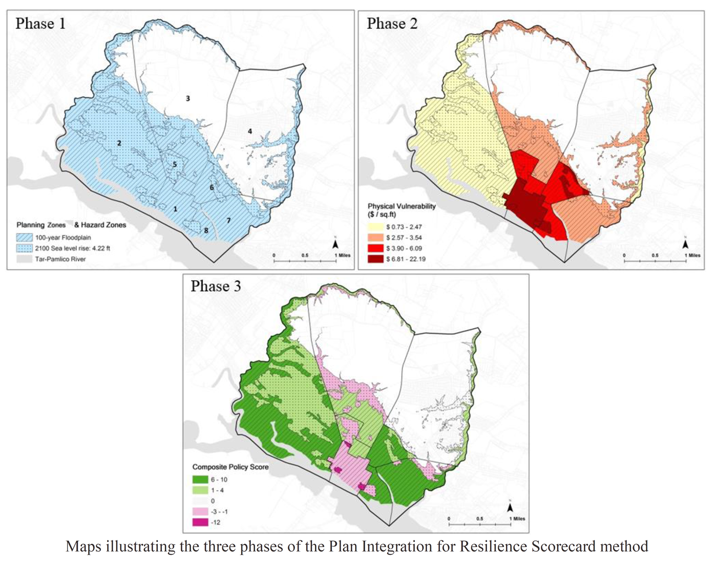
Creating a Plan Integration for Resilience Scorecard is a three-phase process.
- First, hazard zones (in this case, current and future floodplains) and planning districts (i.e. neighborhoods) are defined and mapped, creating neighborhood-scale units for improved analysis.
- Next, physical and social vulnerability are determined for each of the new units using publicly available data.
- Finally, documents in the community’s network of plans are evaluated and scores are given to districts for each policy that (a) influences land use, (b) affects vulnerability, and (c) can be spatially assigned. Scores are then summed for each hazard zone in each planning district. Higher scores indicate greater policy focus on reducing vulnerability. Negative scores indicate that the sum of applicable policies may actually increase vulnerability.
Implications for Communities
After applying the Plan Integration for Resilience Scorecard method in a diverse sample of coastal cities, it is evident that conflicts exist within many community networks of plans, and that strong policy scores do not always align with areas of greatest need. Even communities with high overall plan scores exhibit some inconsistencies within their plan networks and mismatches between policies and vulnerabilities. While they may otherwise go unnoticed, such findings are easily recognized using the scorecard method. This spatial plan evaluation can provides planners and decision-makers with the motivation and information they need to better integrate their networks of plans and more effectively build resilience throughout their communities.
Next Steps
The research team is currently in the process of analyzing and publishing its findings and exploring further applications for the Plan Integration for Resilience Scorecard. Additionally, with the assistance of three pilot communities and a national advisory board of academics and specialists, a guidebook is being developed to facilitate use of the scorecard method by planning and city management staff.
[Additional project team members: Dr. Philip Berke (PI); Siyu Yu; Jaekyung Lee; Jaimie Hicks Masterson]